
Garmin eTrex SE
4.2Editor score
Up to 168 hours battery
Multi-GNSS satellite support
Water-resistant IPX7 design
Navigating the Appalachian Trail requires reliable technology to ensure safety and enjoyment during your journey. A quality GPS device helps you stay on track through dense forests and remote sections where cell service fails completely.
We evaluated the top GPS units based on battery life, display readability, and mapping capabilities suitable for long-distance hiking. Each product was assessed for ruggedness and ease of use in challenging outdoor environments.
Each pick highlights specific strengths for different hiker needs from budget-friendly options to premium models with advanced sensors. Prices fluctuate frequently so check current listings before making your final purchase decision.
4.2Editor score

4.6Editor score

4.6Editor score
As an Amazon Associate we earn from qualifying purchases.
The following table provides a side-by-side comparison of all ten selected devices highlighting key specifications and features relevant to Appalachian Trail hikers.
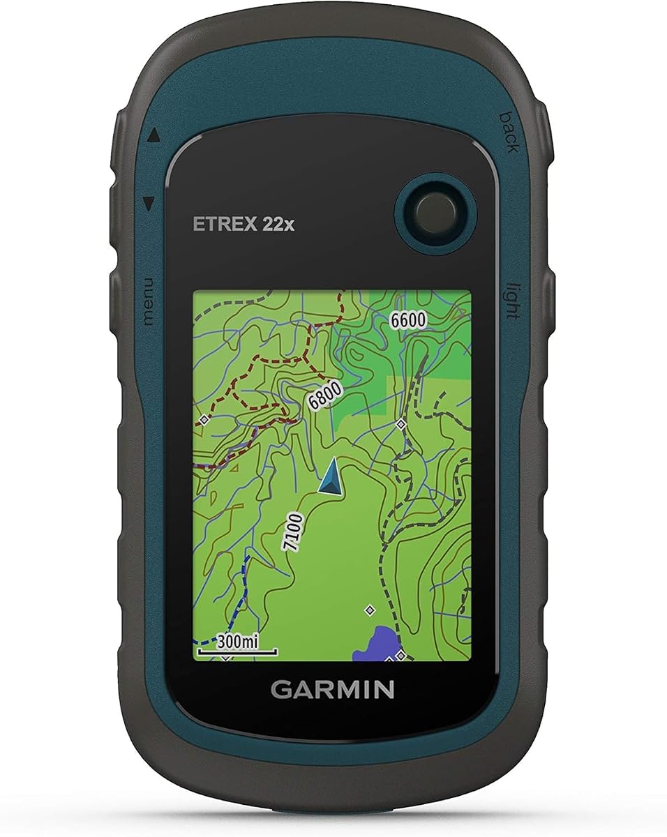





The Garmin eTrex 22x stands out as a reliable choice for Appalachian Trail hikers seeking dependable navigation without excessive complexity. It holds a strong rating from users who value consistency and durability on the trail.
We may earn a commission when you buy through this link, at no additional cost to you.
Its standout quality lies in the preloaded Topo Active maps which provide routable roads and trails essential for planning segments of the AT. The support for both GPS and GLONASS satellite systems ensures better tracking in challenging environments with dense tree cover.
While the screen is smaller than modern smartphone displays it remains highly readable even in bright sunlight thanks to the 240 by 320 pixel resolution. The battery life is exceptional offering up to twenty five hours in GPS mode on just two AA batteries.
This device is ideal for hikers who prioritize battery longevity and simplicity over touch interfaces or large screens. If you need a sturdy tool that focuses on core navigation functions the eTrex 22x delivers excellent performance.
Dual satellite system support helps maintain a lock on your location even in deep valleys or thick forests where signal strength often drops.
The efficient power usage allows for multi-day trips without needing frequent battery changes or external power sources during your hike.
We may earn a commission when you buy through this link, at no additional cost to you.
The eTrex 32x builds on the success of the 22x by adding critical sensors that enhance navigation accuracy during elevation changes. It is well suited for hikers who want to track altitude gain and heading with precision.
We may earn a commission when you buy through this link, at no additional cost to you.
The addition of a 3-axis compass and barometric altimeter allows you to maintain accurate heading even when stationary and provides elevation data crucial for mountainous sections of the AT. This data helps you anticipate terrain challenges before reaching them.
Like its sibling it features the same sunlight readable display and impressive battery life. The micro SD card slot offers flexibility to load custom maps or additional data sets beyond the preloaded content.
This model is best for hikers who need more than just location tracking and want tools to monitor their progress and orientation in variable weather conditions. It strikes a balance between advanced features and usability.
The barometric altimeter gives you real-time elevation data which is vital for knowing when to expect steep ascents or descents on the trail.
The ability to insert a micro SD card means you can carry regional topographic maps or detailed trail guides for specific sections of your hike.
We may earn a commission when you buy through this link, at no additional cost to you.
The Garmin eTrex SE is an outstanding option for budget-conscious hikers who refuse to compromise on core performance and battery endurance. It delivers essential navigation capabilities in a lightweight package designed for long duration use.
We may earn a commission when you buy through this link, at no additional cost to you.
Its most impressive feature is the battery life which can last up to one hundred and sixty eight hours in standard mode. This ensures you can go on multi-week thru-hikes without worrying about power availability in the wild.
The device supports multiple global navigation satellite systems including GPS GLONASS and Galileo which improves accuracy in difficult terrain. It is also water resistant to IPX7 standards meaning it can withstand rain and accidental submersion.
This unit is perfect for hikers who need a reliable backup or primary device that prioritizes endurance over complex functionality. It pairs well with the Garmin Explore app for planning and updates while on the trail.
The expedition mode extends battery life even further allowing you to track your location for weeks at a time on a single charge of AA batteries.
Pairing with a smartphone enables you to receive smart notifications and software updates without needing a computer connection back home.
We may earn a commission when you buy through this link, at no additional cost to you.
This handheld GPS offers a compelling alternative for hikers who prefer a larger display for map reading and modern charging options. It provides essential features found in more expensive units at a competitive price point.
We may earn a commission when you buy through this link, at no additional cost to you.
The 3.2 inch screen is significantly larger than many dedicated GPS units making it easier to view detailed maps and waypoints without squinting. It is sunlight readable and features physical buttons for easy control while wearing gloves.
With 32 GB of internal memory you can load extensive map data for the entire Appalachian Trail and beyond. The inclusion of USB-C charging is a modern convenience that simplifies power management during long trips.
While user ratings are slightly lower it remains a functional tool for those who need a rugged device with a big screen and high storage. It is a solid choice for budget buyers seeking specific display and connectivity features.
The USB-C port allows you to use the same cable as many smartphones and power banks reducing the gear you need to carry on your hike.
The larger screen dimensions improve readability of trail names and elevation data helping you make quick navigation decisions on the move.
We may earn a commission when you buy through this link, at no additional cost to you.
The GPSMAP 65s represents the pinnacle of handheld GPS technology with Multi-Band support that ensures optimal accuracy in challenging locations. It is designed for hikers who demand the highest level of reliability and detail.
We may earn a commission when you buy through this link, at no additional cost to you.
Multi-Band technology allows the device to use multiple frequencies from satellite systems which minimizes signal interference from trees and canyons. This results in a much stronger and more accurate location fix compared to standard units.
The 2.6 inch color display provides ample space for viewing detailed topographic maps and terrain features. It includes a 3-axis compass and barometric altimeter for comprehensive navigation data without needing external sensors.
If you are tackling difficult sections of the trail where precision matters most this model offers advanced features that justify the investment. It is an excellent choice for serious hikers who want the best available navigation.
Multi-Band capability significantly reduces signal loss in dense forests or deep valleys ensuring you stay connected to the satellite network.
The included federal public land maps provide detailed information on land boundaries which is useful for understanding where public trails are located.
We may earn a commission when you buy through this link, at no additional cost to you.
While not a GPS device this book serves as an essential companion for planning and understanding the history of the Appalachian Trail. It is the only illustrated book officially published with the Appalachian Trail Conservancy.
We may earn a commission when you buy through this link, at no additional cost to you.
The book includes a removable full-size copy of the official National Park Service map which is invaluable for planning routes and checking campsite locations. It offers a detailed visual guide to the entire path from Maine to Georgia.
With over three hundred contemporary images and unpublished historical photos it inspires hikers with the beauty and significance of the trail. It provides insights into conservation efforts and the day-by-day experience of a thru-hike.
This resource is perfect for those preparing for a hike who want to understand the context and history of the path they will walk. It complements digital tools by offering a static backup reference for route planning.
The inclusion of the official Park Service map ensures you have an accurate and authoritative reference for trail segments and shelter locations.
Reading about the history of the trail and the volunteers who built it can provide motivation during challenging moments on your hike.
We may earn a commission when you buy through this link, at no additional cost to you.
The Foretrex 401 offers a unique approach to navigation by placing the GPS on your wrist for hands-free tracking. This design is ideal for hikers who want to keep their hands free for climbing or managing gear.
We may earn a commission when you buy through this link, at no additional cost to you.
Its compact size makes it one of the most lightweight navigation options available while still offering essential features like HotFix satellite prediction for faster location locking. The waterproof design ensures it survives rain and river crossings.
The TracBack feature allows you to retrace your path to the starting point using the same route you took which is a vital safety feature if you get off track. It also includes a trip computer and electronic compass.
This device is best for minimalist hikers who want a discreet and reliable backup or primary GPS without the bulk of a handheld unit. It is a great tool for those who prioritize mobility and hands-free functionality.
Having GPS on your wrist means you do not have to stop and pull out a device to check your location or heading while walking.
The TracBack function automatically saves your track so you can easily navigate back to camp or your starting point if you get lost.
We may earn a commission when you buy through this link, at no additional cost to you.
The eTrex 20x is a classic model that continues to serve hikers with its robust display and memory capabilities. It offers an upgraded resolution over previous versions to improve readability of maps and text.
We may earn a commission when you buy through this link, at no additional cost to you.
With three point seven gigabytes of internal memory and a microSD slot you have plenty of space to load custom topographic maps for different regions. This flexibility is essential for hikers who want to carry detailed maps of the entire trail.
The WAAS enabled GPS receiver ensures precise location locking in open areas and the water resistant design handles unexpected weather. It provides a stable platform for navigation without relying on touch screens.
This device is suitable for those who prefer a straightforward interface with ample storage for maps. It is a reliable companion for day hikes or long-distance trips where detailed map storage is a priority.
The enhanced resolution helps distinguish between trail types and terrain features on the map more clearly than older models.
Loading high resolution topographic maps requires space and the internal plus expandable memory ensures you can carry all the maps you need.
We may earn a commission when you buy through this link, at no additional cost to you.
This book tells the inspiring story of Emma Gatewood who became the first person to thru-hike the Appalachian Trail. It offers a perspective on the human spirit and perseverance that is essential for understanding the trail's legacy.
We may earn a commission when you buy through this link, at no additional cost to you.
Written with access to Gatewood's diaries and interviews it paints a vivid picture of the challenges she faced in the 1950s. The book highlights how her journey brought public attention to the trail and saved it from neglect.
For modern hikers reading this story provides a deep connection to the history of the path they walk. It serves as a reminder of the resilience required to complete the journey and the community built along the way.
This resource is perfect for those who want to feel connected to the past and motivated by the achievements of early hikers. It adds a layer of emotional depth to your hiking adventure.
Understanding the history of the trail through the eyes of the first thru-hiker enriches your appreciation for the landscape and shelters.
Reading about her journey can provide mental strength during difficult days on the trail when you need a boost of inspiration.
We may earn a commission when you buy through this link, at no additional cost to you.
This guide covers some of the most beautiful hiking trails in the northeastern United States including portions of the Appalachian Trail. It is a valuable resource for planning sections of your hike within these states.
We may earn a commission when you buy through this link, at no additional cost to you.
Featuring detailed maps and stunning color photographs it helps you visualize the terrain and select hikes that match your ability. It includes expert guidance on trail conditions and points of interest along the way.
For hikers traveling through Maine New Hampshire Vermont or Massachusetts this book offers insights into the region's best outdoor experiences. It complements your digital tools by offering curated recommendations and visual aids.
This guide is ideal for those who want to explore the broader hiking culture of the Northeast beyond just the main trail. It enhances your trip planning with local knowledge and scenic suggestions.
The guide highlights local landmarks and scenic spots that might not appear on standard GPS maps.
High quality photos help you decide which hikes to prioritize based on the scenery and difficulty levels.
We may earn a commission when you buy through this link, at no additional cost to you.
Choosing the right GPS involves understanding the specific demands of the Appalachian Trail and matching them to device features.
Battery life is perhaps the most critical factor for long-distance hiking. A device that lasts for 20 hours or more ensures you can hike multiple days without needing to recharge. Look for models that use standard batteries or offer extended expedition modes.
The display must be readable in direct sunlight and large enough to show trail details clearly. A high-resolution color screen helps distinguish between different trail types and terrain features without strain.
Modern devices should support multiple satellite systems like GPS GLONASS and Galileo. This multi-GNSS support improves tracking accuracy in dense forests and steep valleys where signals might be weak.
Hiking on the AT exposes gear to rain dust and bumps. A device with a high water-resistance rating like IPX7 or higher ensures it survives the elements and accidental drops.
Ensure the device comes with preloaded topographic maps or supports map loading via memory cards. Access to detailed trail maps is essential for navigation and route planning on the AT.
Physical buttons are often preferred over touch screens for hiking because they work with gloves and are easier to operate while moving. The interface should be intuitive to prevent frustration in stressful situations.
Every ounce matters on a long hike so consider the weight and size of the GPS. A lightweight model reduces fatigue and takes up less space in your pack.
Check if the device can pair with smartphones or apps for software updates and trip planning. Compatibility with popular hiking apps can enhance your overall navigation experience.
Before your hike fully charge the device or insert fresh batteries. Test all functions including the compass and map loading to ensure everything is working correctly in a safe environment.
During your hike check your position regularly to confirm you are on the correct trail. Mark waypoints for water sources and shelters so you can navigate back if needed. Keep the device dry and protected from extreme heat.
After the hike clean the device gently to remove dirt and moisture. Update the maps regularly via the companion app to ensure you have the latest trail data. Store the device in a dry place to protect the electronics.
While paper maps and guides are useful a GPS provides a reliable backup for navigation especially in remote areas. It enhances safety by allowing you to track your location and retrace your steps if you get off track.
Smartphones can work but they generally have shorter battery life and are less rugged than dedicated GPS units. If you use a phone ensure you have a power bank and offline maps installed for reliable use.
Most devices allow you to download maps via a companion app or a computer. You can transfer map files to the internal memory or a microSD card depending on the model.
Always carry spare batteries or a power source. If the battery dies use paper maps and compass skills to continue navigation. Knowing basic orienteering is essential for safety.
Yes modern GPS units with multi-satellite support maintain high accuracy in mountainous terrain. Features like WAAS and HotFix help improve signal lock in difficult environments.
Most handheld GPS units are designed to work offline without needing a cellular connection. They rely solely on satellite signals so they are reliable in remote areas with no service.
The Garmin eTrex 22x and GPSMAP 65s stand out as top choices for reliability and advanced features respectively. Your selection depends on how much you value battery life versus sensor accuracy and display quality.
Prioritize battery life and durability over extra features if you plan on a long thru-hike. A simple tool that lasts for weeks is better than a complex device that requires frequent charging.
Remember that prices change frequently so verify current listings before purchasing. Invest in a device that matches your hiking style and budget to ensure a safe and enjoyable trail experience.